New Updated Roberts Hill Trail Map
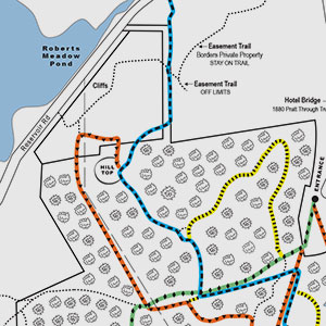
All major and minor trails were recently GPS mapped by trail volunteer Dave Litterer and a new map has been developed by LCA volunteer, Heidi Stevens.
The Blue trail has an entrance on Dimock Street and the Blue trail from Musante Beach is now blazed. Follow the Blue trail to the summit and enjoy a beautiful view recently opened up by the City’s professional forester. The Green trail is a historical route, a section of the 1812 stage route to Albany. Its’ entrance is at the end of Water Street and is now clearly marked and leads out to Chesterfield Road through a narrow leg of conservation land. The Orange trail is an inner loop off of the Green trail and follows the old power line path west of the summit, comes around and up the north side of the summit and connects with the blue trail. Another Orange trail link has been blazed from Main Street to Water Street. Small connector trails are marked with yellow. There are also several small trails without blazes that have been added to the map.
Get out and hike Robert’s Hill!